1650 FULLER Pisgah - Sight Of Palestine HOLY LAND ISRAEL Bible JUDAICA Plates MAPS
Item History & Price
[Middle East - Palestine, Israel, Lebanon, Syria, Egypt - Topography, Geography, History]
[Biblical Geography] [Maps & Cartography - Middle East] [Jerusalem][Judaica - History of Jews]
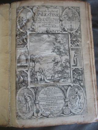
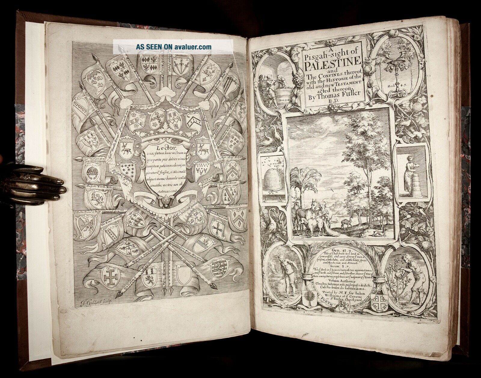
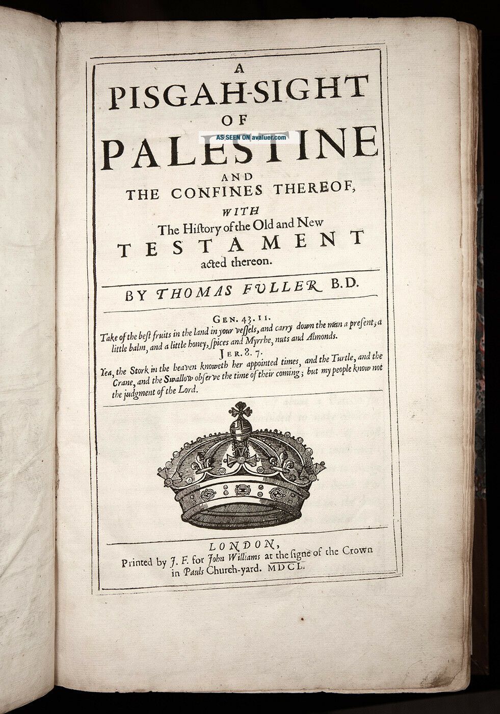
Printed in London, by J.F. for John Williams, 1650.Text in English (with some words/passages in Latin Greek and Hebrew). Illustrated with a splendid extra engraved title-page, armorial frontispiece and numerous double-page copper-engraved plates and maps (most signed by Thomas Cross, John G...oddard, William Marshall, and Robert Vaughan).FIRST EDITION of Fuller's important, richly illustrated geographical and historical account of the Holy Land, and "PROBABLY THE FIRST BIBLE ATLAS WRITTEN IN ENGLISH" (Ian Hopkins)."Pisgah-Sight is one of the great books on the topography of the Holy Land" (Maps of the Holy Land, 130).Fuller's work is noted for its splendid maps of the Holy Land, elaborately detailed with vignettes, emblems and scenes."This curious and singular work is not a mere geographical work, but contains many things relating to Jewish antiquities, and to the manners and customs of the people" (Lowndes, 848).Based on printed sources rather than actual travel, Fuller's great work reflects the European interest at the time in the topography of the Holy Land, as well as the Ark of the Covenant, the Tabernacle, and the Temple, all presumed of divine origin.To finance this publication Fuller found individual sponsors for each section of the text. Each sponsor's support is commemorated in a cartouche of an engraved plate.Fuller was John Milton's contemporary and his (and his book's) connections to Milton have been noticed by researchers:
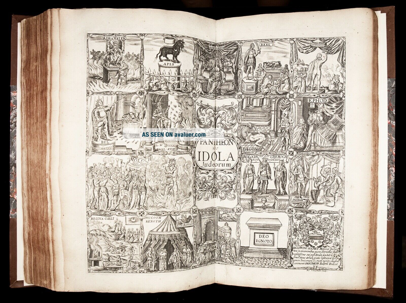
"Miltonists have cause to notice [...] the genial, large-minded, learned, witty, and prolific Thomas Fuller, divine and man of letters, who was Milton's exact contemporary and a student at Cambridge during Milton's years there, [...], and who in 1642 was one of the earliest writers to allude (disapprovingly) to Milton's first pamphlet, Of Reformation. The Miltonist may be led to the Pisgah-Sight in particular by ANNOTATIONS TO PARADISE LOST, WHICH POINT TO FULLER'S BOOK AS A CONTEMPORARY AUTHORITY FOR BIBLICAL TOPOGRAPHY and especially for the appearances, habits, and haunts of those of those Canaanite idols who seduced the Israelites from their allegiance to the true God." (F. Sandler, Thomas Fuller's Pisgah-Sight of Palestine as a Comment on the Politics of Its Time, Huntington Library Quarterly, Vol. 41, No. 4 (Aug., 1978), pp. 317)."Although maps of the Holy Land have been produced for many centuries, the concept of a bound set of maps with an explanatory text is more recent and, at least as far as this country is concerned, is of 17th century origin. The man responsible for making this type of work popular was Thomas Fuller. [...] Coleridge described him as 'incomparably the most sensible, the least prejudiced, great man of an age that boasted a galaxy of great men'. His most significant work, however, may in retrospect be the lesser known 'Pisgah Sight of Palestine' which was an attempt to write a geographical description of the lands of the Bible with a series of maps."Published in 1650, five years before his Church History of Britain, the Pisgah Sight became popular at that time as an English equivalent of the Theatrum Terrae Sanctae by Christian Adrichem and represents probably the first Bible atlas written in English."There are a number of parallels between Fuller's work and that of Adrichem and other contemporaries especially in the design and details of the maps. [...] He certainly sought to impress in all he did and Coleridge again remarked that 'wit was the stuff and substance of Fuller's intellect'. His maps contain imaginary coats of arms of the twelve tribes as well as the arms of his patrons and numerous pictures, as was the custom of the time. Skelton reminds us that maps at that time tended to sell more on appearance than on accuracy and this would no doubt apply equally to Fuller's work. [...]"In fact as far as the text is concerned, Fuller's main source of information is the Bible itself. The tribal boundaries and the nature of the land are described in detail based largely on the Scriptural evidence with proof texts and references. [...] There are also references to classical and medieval writers such as Strabo and Pliny and some discussion of differences of opinion. [...] [Fuller] argues strongly for the Biblical statements on the fertility of Palestine quoting Strabo and St. Jerome at length in support of this. His knowledge of the country is, however, mixed. He defends the fertility of the land at one point by claiming that the wilderness areas were 'no more than a woody retiredness from public habitation', a statement which would be impossible from anyone who had actually been to the wilderness east of the Mount of Olives. There are, on the other hand, some detailed investigations of geographical features such as the Dead Sea using ancient writers as well as the Scriptures. [...]"Apart from the text, however, the Pisgah Sight is illustrated by a number of maps. [...] As was usual with maps of the Holy Land up to the present century, the details of ancient Palestine were considered more important than the data available of the contemporary scene. Nevertheless there was a clear attempt to present them with a clarity imd an accuracy which would make them useful."One important feature of the maps in the Pisgah Sight was that they have a uniformity of style despite the fact that three named engravers were used and there were in addition five anonymous maps. The engravers used were John Goddard, Robert Vaughan and W. Marshall [...]. There is some variation in the pictorial detail used to depict the cities but certain consistent symbols were used by all engravers to such effect that it becomes very difficult to decide which, if any, of them were responsible for the anonymous maps. Clearly there was a master hand controlling the process and this was almost certainly Fuller himself. His attention to detail and accuracy was such that he even had a specific symbol (a banner) for any site whose location was uncertain. [...]"A detailed comparison between his cartographic products and those of other contemporaries [...] [shows that, although] Fuller's knowledge of the Holy Land was less than precise, [...] the shapes of the Dead Sea and of the Sea of Galilee [on Fuller's maps] are more accurate than in most other contemporary maps. Both approximate to their true shape in general outline compared with Speed's map which has a crescent shaped Dead Sea and a very irregularly shaped Galilee. Ortelius in his Theatru1n Drbis Terrarum of 1584 had both seas far less accurately portrayed than is the case with Fuller [...]. William Blaew's Terra Sancta (1629) shows both seas very erroneously and Tilemann Stella (1579) depicts a Dead Sea curved like a new moon! [...] In this respect Fuller's cartography was a distinct improvement. [...]"We cannot conclude by ascribing to Fuller's 'Pisgah Sight' a scientific exactitude which would have been untypical of his age and which would in any case have made his work impossible to sell commercially. However, while the maps have the usual cartouches, embellishments and fancies, they appear to be a genuine attempt to obtain some sort of precision. In the text also, Fuller's intention is to convey accurate information based on the Biblical text and classical authors. Today we regard the Pisgah Sight as a decorative and quaint product of a pious age, but it is significant as the first genuine attempt in English to convey, in both textual and cartographic form, the geography of the Holy Land and as such can justly be regarded as our first modern Bible atlas." (Ian W. J. Hopkins, Fuller's Pisgah Sight of Palestine: A Seventeenth-Century Bible Atlas, The Evangelical Quarterly, Vol. LIV No. 3 (1982), p.169-173)Thomas Fuller (1608 - 1661) was a British scholar, preacher, and one of the most witty and prolific authors of the 17th century. Fuller was educated at Queens' College, Cambridge. He was appointed preacher at the Chapel Royal, Savoy, London, in 1641, where he officiated until 1643, when the deteriorating political situation (beginning of the English Civil Wars) forced him to leave London for Oxford. For a time during the fighting, he served as chaplain to the Royalist army and, for nearly two years, was in attendance on the household of the infant princess Henrietta at Exeter. He returned to London in 1646 and wrote Andronicus, or the Unfortunate Politician, a satire against Oliver Cromwell. In 1649 he was given the parish of Waltham Abbey, Essex, where he became a friend of Izaak Walton. Fuller was again appointed to a pulpit in London (1652). There he completed The Church-History of Britain (1655), notable for its number of excellent character sketches. Upon the reestablishment of the monarchy (1660), all Fuller's ecclesiastical privileges were restored, and he became a doctor of divinity at Cambridge.By enriching his factual accounts with descriptions of psychological oddities and other details of human interest, Fuller widened the scope of English biographical writing. His History of the Worthies of England, published posthumously in 1662, was the first attempt at a dictionary of national biography. He was also a historian who gathered facts from original sources, producing works that provide much valuable antiquarian information. He acquired a reputation for quaintness because his writings abound with epigrams, anecdotes, puns, and other conceits, but he also paid careful attention to literary form. Fuller's The Holy State, the Profane State (1642) is an entertaining collection of character sketches important to the historian of English literature.Bibliographic references:Wing F2455. Gibson SVIII:1. Cox I:208; Röhricht 1070; Lowndes, 848.Physical description:Folio, leaves measure 34 cm x 22 cm. Rebound in pleasing modern half-calf over marbled boards; spine with raised bands and a pair of gilt-lettered labels. Early (perhaps original?) olive-green paper wrappers (both front and rear) bound in.Pagination: [12], 434 [i.e. 447], [1], 202, [18] (pagination somewhat erratic, as some of the plates are included in the pagination, while some are not).
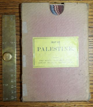
Complete, except for the rare folding map of Palestine, and the last plate ("Fragmenta Sacra").
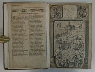
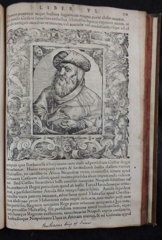
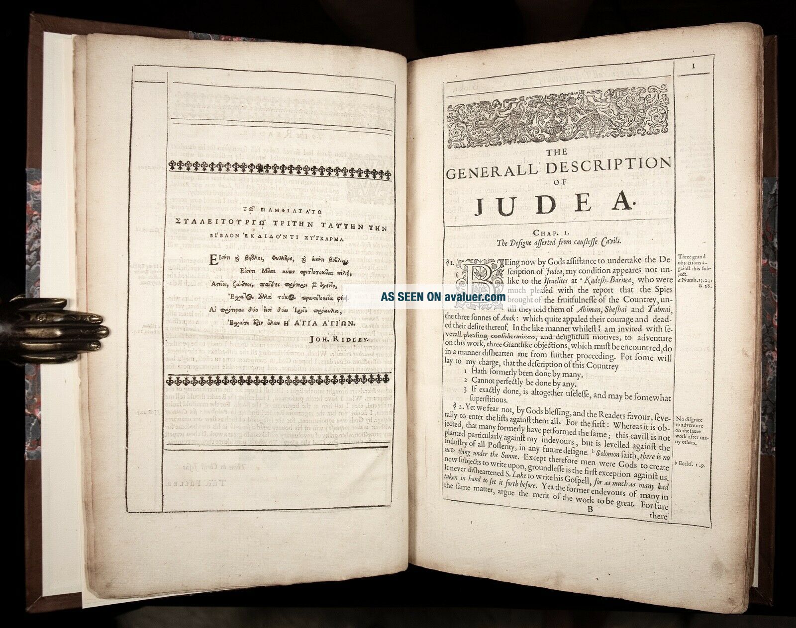
With all text entirely complete, and Illustrated with: an armorial frontispiece, fine historiated extra engraved title-page, and 26 (of 28) FINE DOUBLE-PAGE ENGRAVED MAPS AND PLATES, comprising:
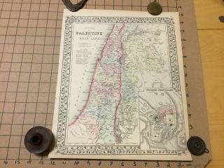
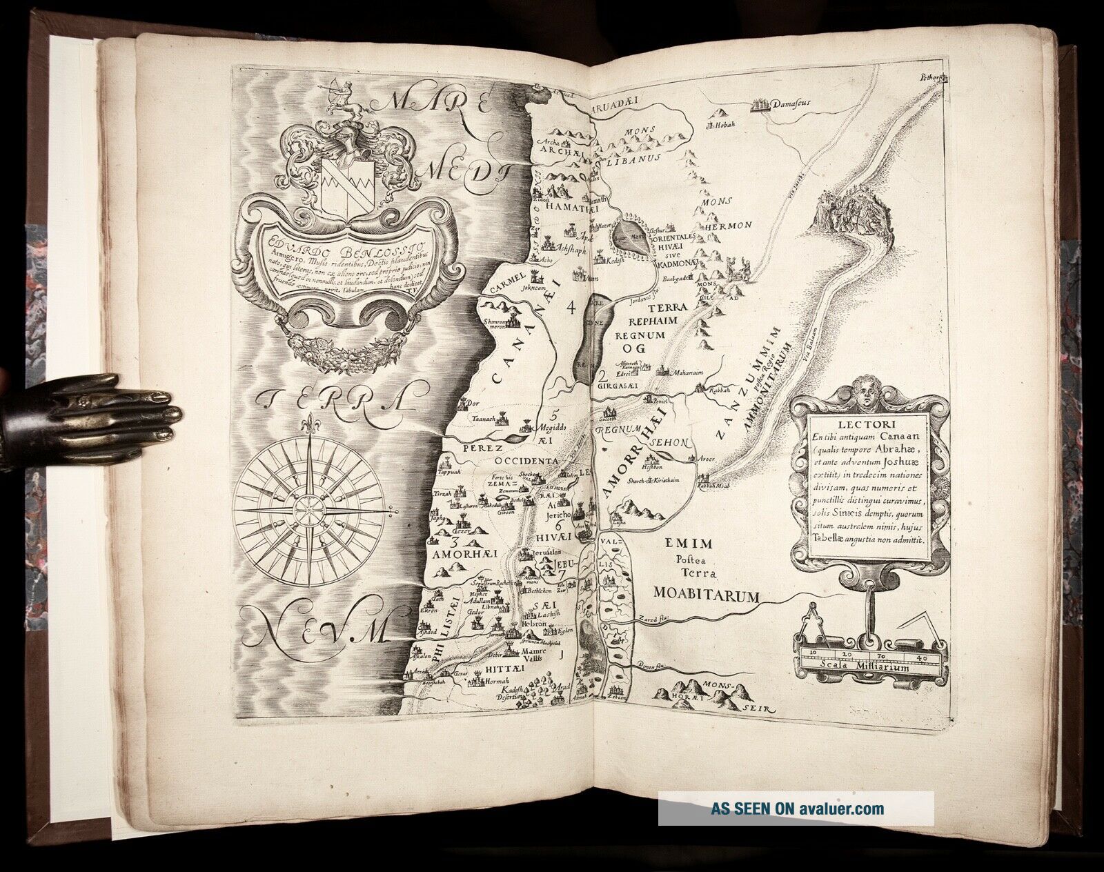
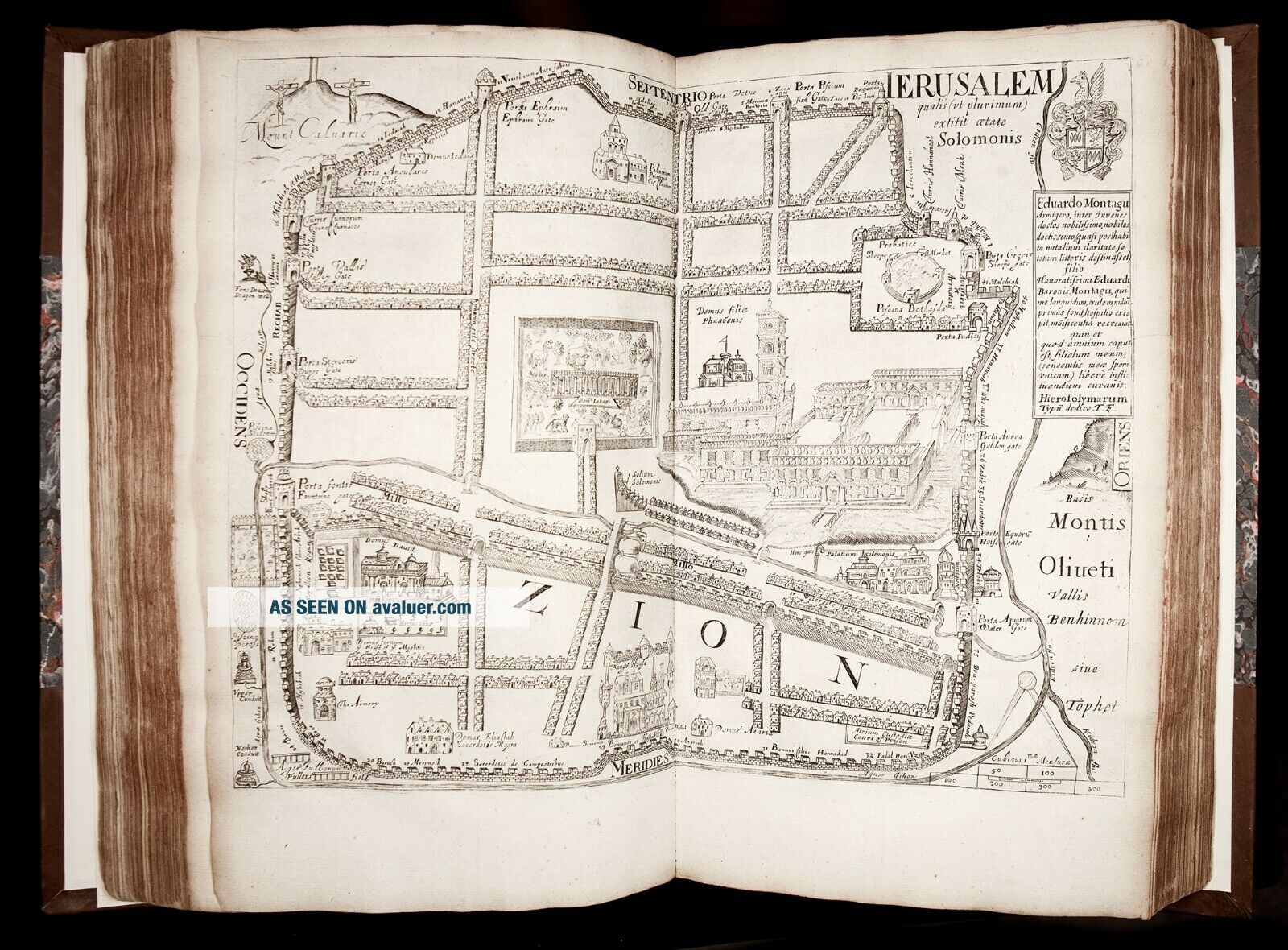
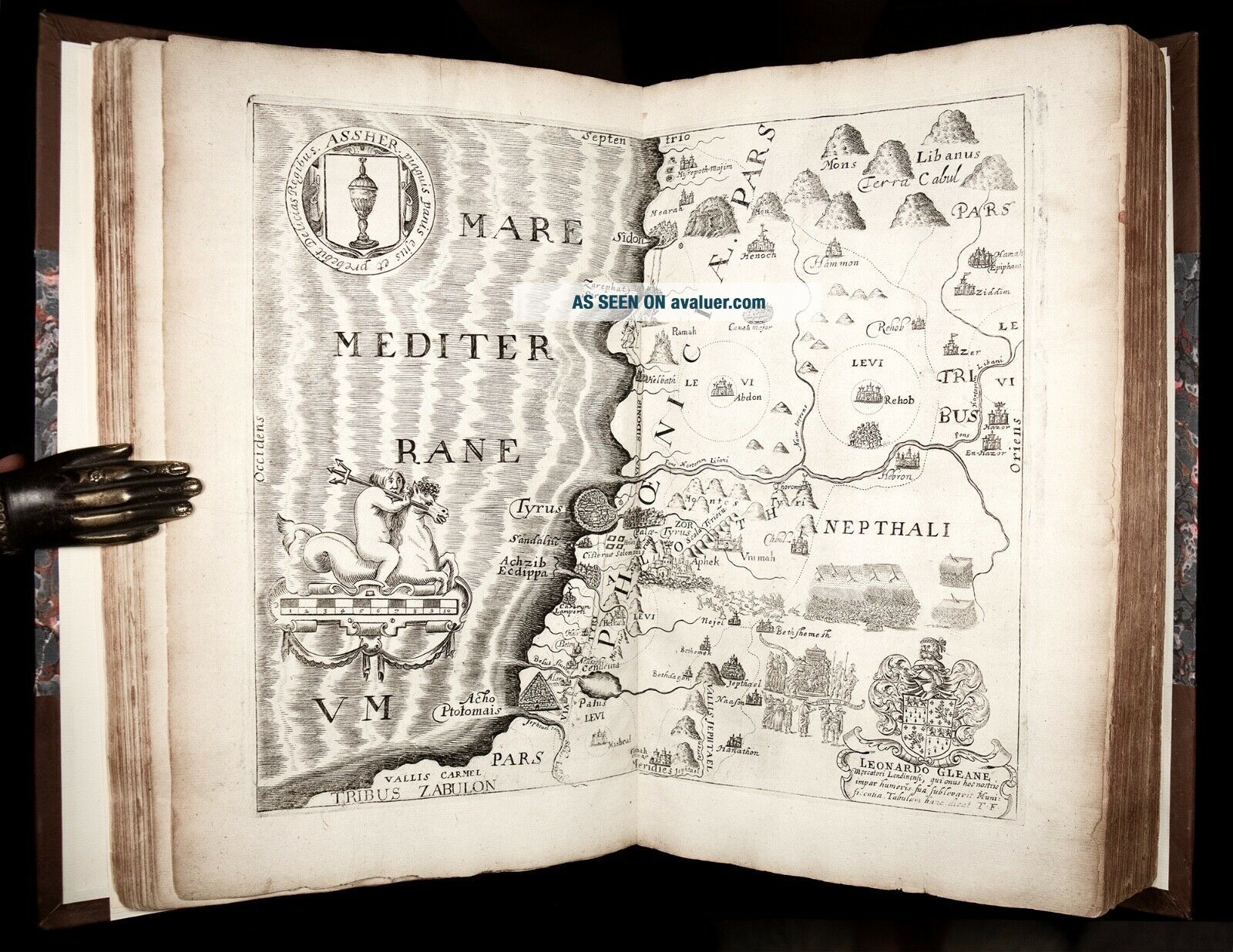
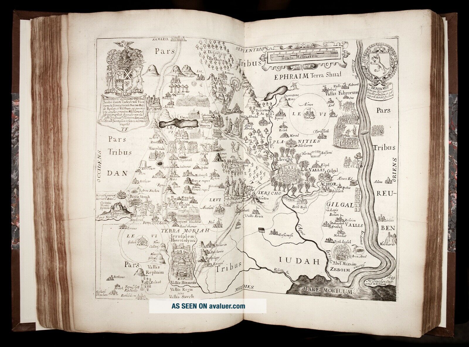
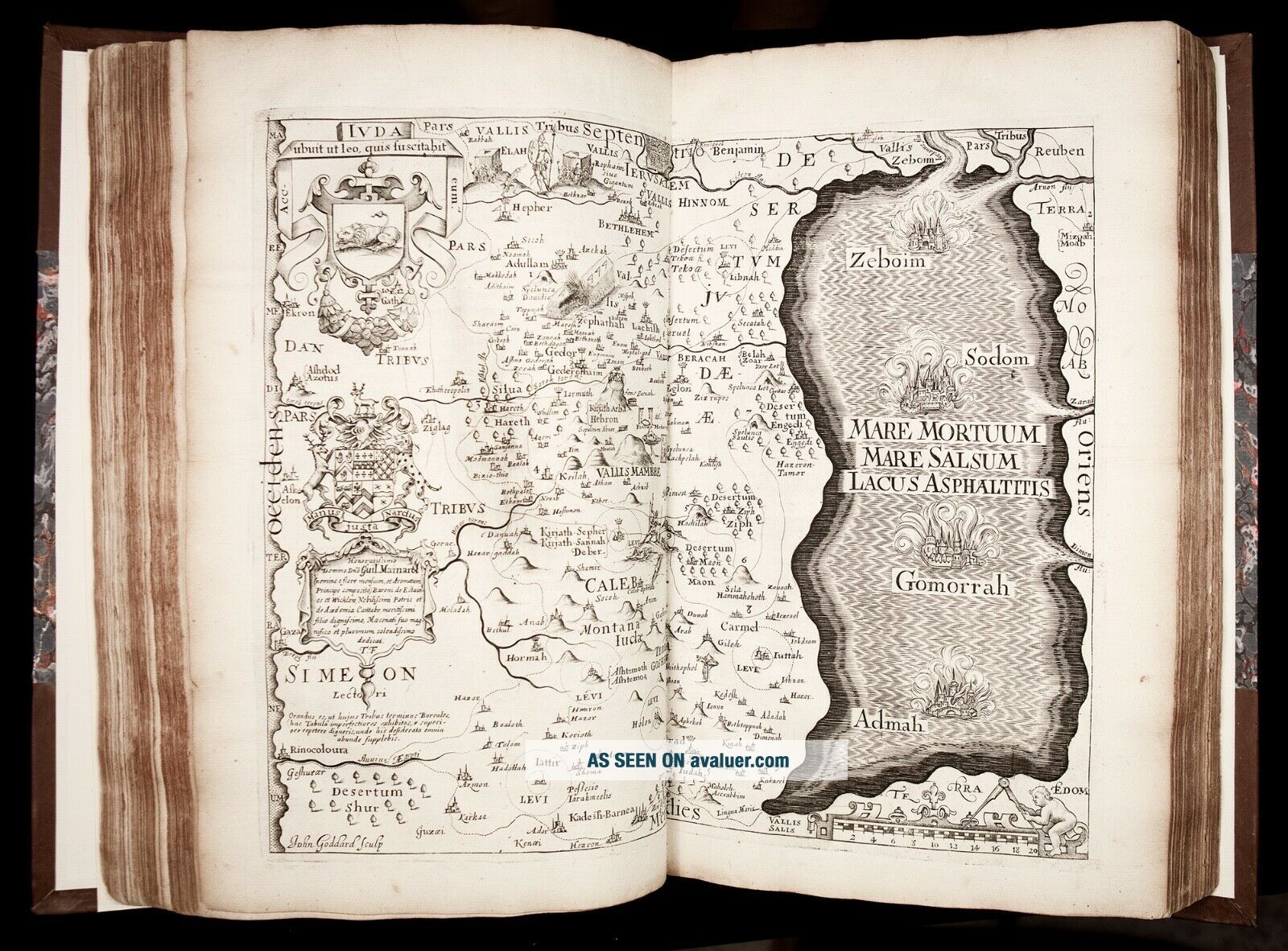
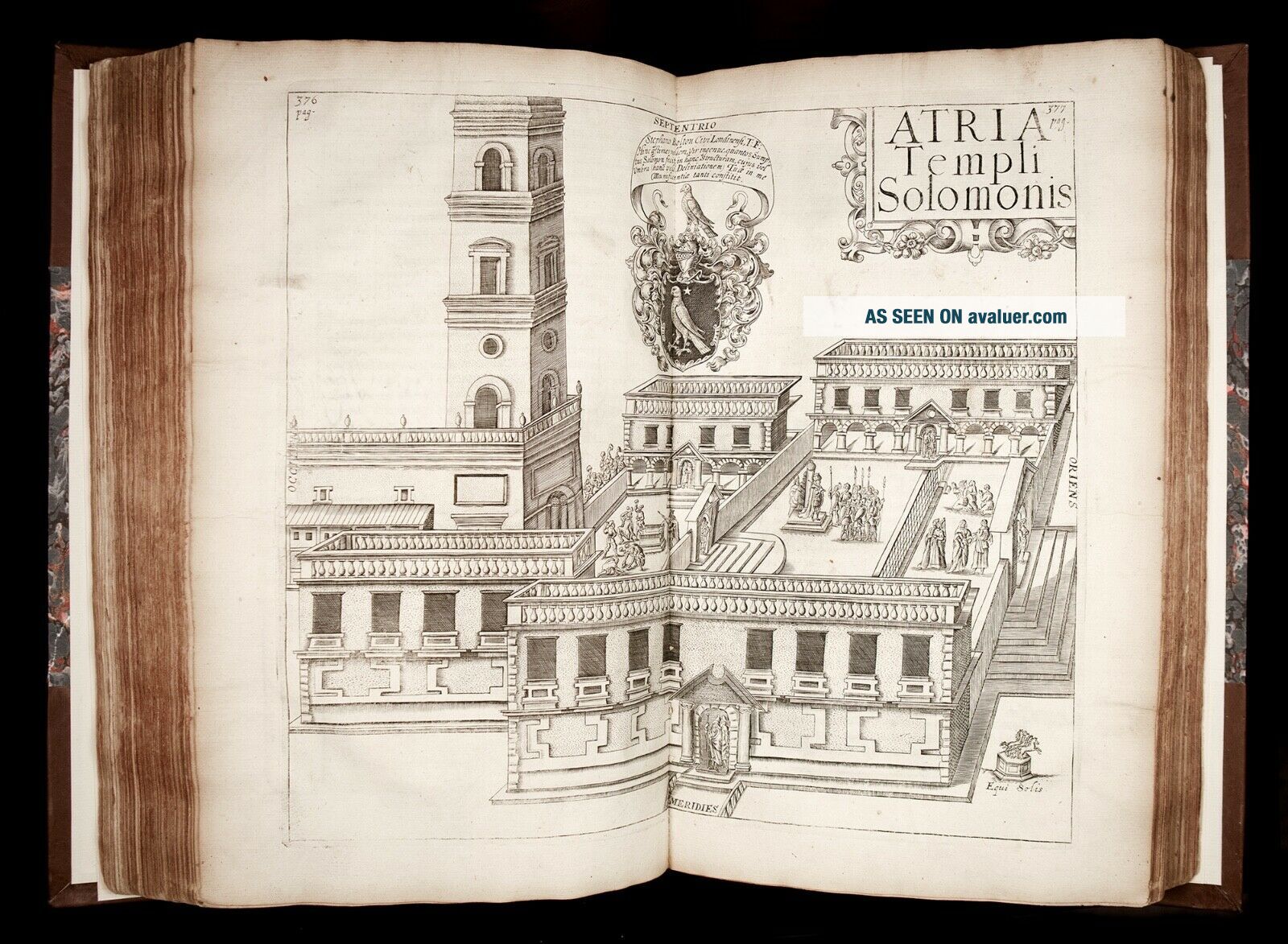
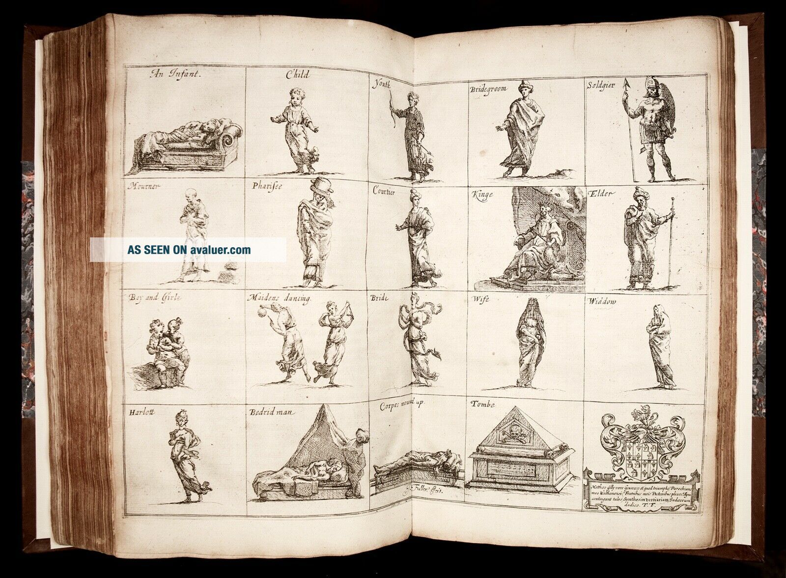
Map of old Canaan; Map of the Tribe of Reuben; Map of the Tribe of Gad; Map of the Tribe of Manasseh beyond Jordan; Map of the Tribe of Naphtali; Map of the Tribe of Asher; Map of the Tribe of Zebulun; Map of Issachar; Map of Manasseh on this side of Jordan; Map of the Land of Ephraim; Map of the Tribe of Dan; Map of the Tribe of Simeon; Map of the Tribe of Benjamin; Map of the Tribe of Judah; Map of the Land of Moriah; Plan of Jerusalem; Plan of Solomon's Temple ("as it was in Christe time"); The Temple of Zorobabel; Plan of Solomon's Courts; Map of Mount Libanus [i.e. Lebanon]; map of Midian, Moab, Ammon & Edom; Map of the wilderness of Paran; Map of Egypt; plate depicting the Tabernacle (Icon Tabernaculi); plate depicting Jewish Habits; plate depicting Jewish Gods (Pantheon sive Idola Judeorum).Numerous woodcut decorative initials, ornamental woodcut head- and tail-pieces.Preliminaries include a dedicatory epistle; a short preface to the reader (both by Fuller), and an epigraph poem in Greek signed 'Joh. Ridley'. (Each of the five books comprising the work has its own dedication.)At the end of the volume is found an Index, preceded by "Necessary directions for the use of the Index", and followed by Errata. Provenance:Formerly in St. Augustine's College at Canterbury, England, with its armorial bookplate pasted on blank verso of the letterpress title; next to a presentation ticket signed by Mrs. Horne of Gore Court [Kent]. Condition:Very Good antiquarian condition. Two bookplates affixed to blank verso of letterpress title (see Provenance above). Some rather light (and mostly marginal) browning. Some plates with light marginal wrinkling (as usual) and a few very minor, harmless closed marginal tears at edges (not affecting any engravings). Several leaves with minor marginal worming near bottom edge (text and engravings not affected). A couple of tiny rust-holes, not affecting legibility.In all, a very nice, fresh, wide-margined example of this sumptuous folio, unwashed and unpressed, and internally completely unrestored, and retaining early, perhaps original, paper wrappers. The impressive double-page plates and maps are in excellent state of preservation.
Please right-click on thumbnails below and choose "open image in a new window" option to see larger images.
[Biblical Geography] [Maps & Cartography - Middle East] [Jerusalem][Judaica - History of Jews]
Printed in London, by J.F. for John Williams, 1650.Text in English (with some words/passages in Latin Greek and Hebrew). Illustrated with a splendid extra engraved title-page, armorial frontispiece and numerous double-page copper-engraved plates and maps (most signed by Thomas Cross, John G...oddard, William Marshall, and Robert Vaughan).FIRST EDITION of Fuller's important, richly illustrated geographical and historical account of the Holy Land, and "PROBABLY THE FIRST BIBLE ATLAS WRITTEN IN ENGLISH" (Ian Hopkins)."Pisgah-Sight is one of the great books on the topography of the Holy Land" (Maps of the Holy Land, 130).Fuller's work is noted for its splendid maps of the Holy Land, elaborately detailed with vignettes, emblems and scenes."This curious and singular work is not a mere geographical work, but contains many things relating to Jewish antiquities, and to the manners and customs of the people" (Lowndes, 848).Based on printed sources rather than actual travel, Fuller's great work reflects the European interest at the time in the topography of the Holy Land, as well as the Ark of the Covenant, the Tabernacle, and the Temple, all presumed of divine origin.To finance this publication Fuller found individual sponsors for each section of the text. Each sponsor's support is commemorated in a cartouche of an engraved plate.Fuller was John Milton's contemporary and his (and his book's) connections to Milton have been noticed by researchers:
"Miltonists have cause to notice [...] the genial, large-minded, learned, witty, and prolific Thomas Fuller, divine and man of letters, who was Milton's exact contemporary and a student at Cambridge during Milton's years there, [...], and who in 1642 was one of the earliest writers to allude (disapprovingly) to Milton's first pamphlet, Of Reformation. The Miltonist may be led to the Pisgah-Sight in particular by ANNOTATIONS TO PARADISE LOST, WHICH POINT TO FULLER'S BOOK AS A CONTEMPORARY AUTHORITY FOR BIBLICAL TOPOGRAPHY and especially for the appearances, habits, and haunts of those of those Canaanite idols who seduced the Israelites from their allegiance to the true God." (F. Sandler, Thomas Fuller's Pisgah-Sight of Palestine as a Comment on the Politics of Its Time, Huntington Library Quarterly, Vol. 41, No. 4 (Aug., 1978), pp. 317)."Although maps of the Holy Land have been produced for many centuries, the concept of a bound set of maps with an explanatory text is more recent and, at least as far as this country is concerned, is of 17th century origin. The man responsible for making this type of work popular was Thomas Fuller. [...] Coleridge described him as 'incomparably the most sensible, the least prejudiced, great man of an age that boasted a galaxy of great men'. His most significant work, however, may in retrospect be the lesser known 'Pisgah Sight of Palestine' which was an attempt to write a geographical description of the lands of the Bible with a series of maps."Published in 1650, five years before his Church History of Britain, the Pisgah Sight became popular at that time as an English equivalent of the Theatrum Terrae Sanctae by Christian Adrichem and represents probably the first Bible atlas written in English."There are a number of parallels between Fuller's work and that of Adrichem and other contemporaries especially in the design and details of the maps. [...] He certainly sought to impress in all he did and Coleridge again remarked that 'wit was the stuff and substance of Fuller's intellect'. His maps contain imaginary coats of arms of the twelve tribes as well as the arms of his patrons and numerous pictures, as was the custom of the time. Skelton reminds us that maps at that time tended to sell more on appearance than on accuracy and this would no doubt apply equally to Fuller's work. [...]"In fact as far as the text is concerned, Fuller's main source of information is the Bible itself. The tribal boundaries and the nature of the land are described in detail based largely on the Scriptural evidence with proof texts and references. [...] There are also references to classical and medieval writers such as Strabo and Pliny and some discussion of differences of opinion. [...] [Fuller] argues strongly for the Biblical statements on the fertility of Palestine quoting Strabo and St. Jerome at length in support of this. His knowledge of the country is, however, mixed. He defends the fertility of the land at one point by claiming that the wilderness areas were 'no more than a woody retiredness from public habitation', a statement which would be impossible from anyone who had actually been to the wilderness east of the Mount of Olives. There are, on the other hand, some detailed investigations of geographical features such as the Dead Sea using ancient writers as well as the Scriptures. [...]"Apart from the text, however, the Pisgah Sight is illustrated by a number of maps. [...] As was usual with maps of the Holy Land up to the present century, the details of ancient Palestine were considered more important than the data available of the contemporary scene. Nevertheless there was a clear attempt to present them with a clarity imd an accuracy which would make them useful."One important feature of the maps in the Pisgah Sight was that they have a uniformity of style despite the fact that three named engravers were used and there were in addition five anonymous maps. The engravers used were John Goddard, Robert Vaughan and W. Marshall [...]. There is some variation in the pictorial detail used to depict the cities but certain consistent symbols were used by all engravers to such effect that it becomes very difficult to decide which, if any, of them were responsible for the anonymous maps. Clearly there was a master hand controlling the process and this was almost certainly Fuller himself. His attention to detail and accuracy was such that he even had a specific symbol (a banner) for any site whose location was uncertain. [...]"A detailed comparison between his cartographic products and those of other contemporaries [...] [shows that, although] Fuller's knowledge of the Holy Land was less than precise, [...] the shapes of the Dead Sea and of the Sea of Galilee [on Fuller's maps] are more accurate than in most other contemporary maps. Both approximate to their true shape in general outline compared with Speed's map which has a crescent shaped Dead Sea and a very irregularly shaped Galilee. Ortelius in his Theatru1n Drbis Terrarum of 1584 had both seas far less accurately portrayed than is the case with Fuller [...]. William Blaew's Terra Sancta (1629) shows both seas very erroneously and Tilemann Stella (1579) depicts a Dead Sea curved like a new moon! [...] In this respect Fuller's cartography was a distinct improvement. [...]"We cannot conclude by ascribing to Fuller's 'Pisgah Sight' a scientific exactitude which would have been untypical of his age and which would in any case have made his work impossible to sell commercially. However, while the maps have the usual cartouches, embellishments and fancies, they appear to be a genuine attempt to obtain some sort of precision. In the text also, Fuller's intention is to convey accurate information based on the Biblical text and classical authors. Today we regard the Pisgah Sight as a decorative and quaint product of a pious age, but it is significant as the first genuine attempt in English to convey, in both textual and cartographic form, the geography of the Holy Land and as such can justly be regarded as our first modern Bible atlas." (Ian W. J. Hopkins, Fuller's Pisgah Sight of Palestine: A Seventeenth-Century Bible Atlas, The Evangelical Quarterly, Vol. LIV No. 3 (1982), p.169-173)Thomas Fuller (1608 - 1661) was a British scholar, preacher, and one of the most witty and prolific authors of the 17th century. Fuller was educated at Queens' College, Cambridge. He was appointed preacher at the Chapel Royal, Savoy, London, in 1641, where he officiated until 1643, when the deteriorating political situation (beginning of the English Civil Wars) forced him to leave London for Oxford. For a time during the fighting, he served as chaplain to the Royalist army and, for nearly two years, was in attendance on the household of the infant princess Henrietta at Exeter. He returned to London in 1646 and wrote Andronicus, or the Unfortunate Politician, a satire against Oliver Cromwell. In 1649 he was given the parish of Waltham Abbey, Essex, where he became a friend of Izaak Walton. Fuller was again appointed to a pulpit in London (1652). There he completed The Church-History of Britain (1655), notable for its number of excellent character sketches. Upon the reestablishment of the monarchy (1660), all Fuller's ecclesiastical privileges were restored, and he became a doctor of divinity at Cambridge.By enriching his factual accounts with descriptions of psychological oddities and other details of human interest, Fuller widened the scope of English biographical writing. His History of the Worthies of England, published posthumously in 1662, was the first attempt at a dictionary of national biography. He was also a historian who gathered facts from original sources, producing works that provide much valuable antiquarian information. He acquired a reputation for quaintness because his writings abound with epigrams, anecdotes, puns, and other conceits, but he also paid careful attention to literary form. Fuller's The Holy State, the Profane State (1642) is an entertaining collection of character sketches important to the historian of English literature.Bibliographic references:Wing F2455. Gibson SVIII:1. Cox I:208; Röhricht 1070; Lowndes, 848.Physical description:Folio, leaves measure 34 cm x 22 cm. Rebound in pleasing modern half-calf over marbled boards; spine with raised bands and a pair of gilt-lettered labels. Early (perhaps original?) olive-green paper wrappers (both front and rear) bound in.Pagination: [12], 434 [i.e. 447], [1], 202, [18] (pagination somewhat erratic, as some of the plates are included in the pagination, while some are not).
Complete, except for the rare folding map of Palestine, and the last plate ("Fragmenta Sacra").
With all text entirely complete, and Illustrated with: an armorial frontispiece, fine historiated extra engraved title-page, and 26 (of 28) FINE DOUBLE-PAGE ENGRAVED MAPS AND PLATES, comprising:
Map of old Canaan; Map of the Tribe of Reuben; Map of the Tribe of Gad; Map of the Tribe of Manasseh beyond Jordan; Map of the Tribe of Naphtali; Map of the Tribe of Asher; Map of the Tribe of Zebulun; Map of Issachar; Map of Manasseh on this side of Jordan; Map of the Land of Ephraim; Map of the Tribe of Dan; Map of the Tribe of Simeon; Map of the Tribe of Benjamin; Map of the Tribe of Judah; Map of the Land of Moriah; Plan of Jerusalem; Plan of Solomon's Temple ("as it was in Christe time"); The Temple of Zorobabel; Plan of Solomon's Courts; Map of Mount Libanus [i.e. Lebanon]; map of Midian, Moab, Ammon & Edom; Map of the wilderness of Paran; Map of Egypt; plate depicting the Tabernacle (Icon Tabernaculi); plate depicting Jewish Habits; plate depicting Jewish Gods (Pantheon sive Idola Judeorum).Numerous woodcut decorative initials, ornamental woodcut head- and tail-pieces.Preliminaries include a dedicatory epistle; a short preface to the reader (both by Fuller), and an epigraph poem in Greek signed 'Joh. Ridley'. (Each of the five books comprising the work has its own dedication.)At the end of the volume is found an Index, preceded by "Necessary directions for the use of the Index", and followed by Errata. Provenance:Formerly in St. Augustine's College at Canterbury, England, with its armorial bookplate pasted on blank verso of the letterpress title; next to a presentation ticket signed by Mrs. Horne of Gore Court [Kent]. Condition:Very Good antiquarian condition. Two bookplates affixed to blank verso of letterpress title (see Provenance above). Some rather light (and mostly marginal) browning. Some plates with light marginal wrinkling (as usual) and a few very minor, harmless closed marginal tears at edges (not affecting any engravings). Several leaves with minor marginal worming near bottom edge (text and engravings not affected). A couple of tiny rust-holes, not affecting legibility.In all, a very nice, fresh, wide-margined example of this sumptuous folio, unwashed and unpressed, and internally completely unrestored, and retaining early, perhaps original, paper wrappers. The impressive double-page plates and maps are in excellent state of preservation.
Please right-click on thumbnails below and choose "open image in a new window" option to see larger images.